

PRESS RELEASE
Friday, June 9, 2017
Protecting Belize City from flooding and storm surge by integrating GIS in urban planning
Belize City, Belize –
With the start of the rainy season on June 1, the need for improved urban design to reduce the risk to and the severity of flooding will become more evident. At the recently held Caribbean Urban Forum 2017, two Belizean professionals demonstrated how technology such as drones, mapping, and modelling using Geographic Information Systems (GIS) can give Belize City an edge.
Dr. Emil Cherrington, a Belizean research scientist at the Earth System Science Center (ESSC), University of Alabama in Huntsville (UAH), and Sue Courtenay, a registered architect, demonstrated how mapping the most flood-prone areas can help developers make the right adaptations needed to address flooding, even during the project design phase.
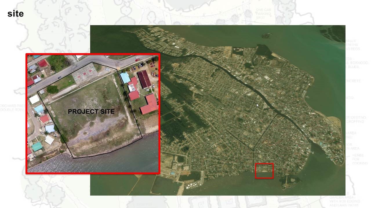
Yarborough area of Belize City, with project site highlighted
This is good news not just for the private sector but also for homeowners who may want to know how much they will need to invest in landfill or to what extent drainage is needed on their property.
Dr. Cherrington created a digital elevation model (DEMO) which enabled the study of an area with a radius of 1 mile, as Courtenay looked at what the information reveals about the adaptations needed for a development in the heart of the Yarborough area, one of the most flood-prone areas of the City.
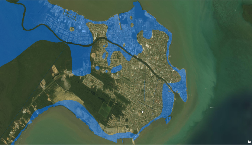
The most flood-prone areas are highlighted in blue
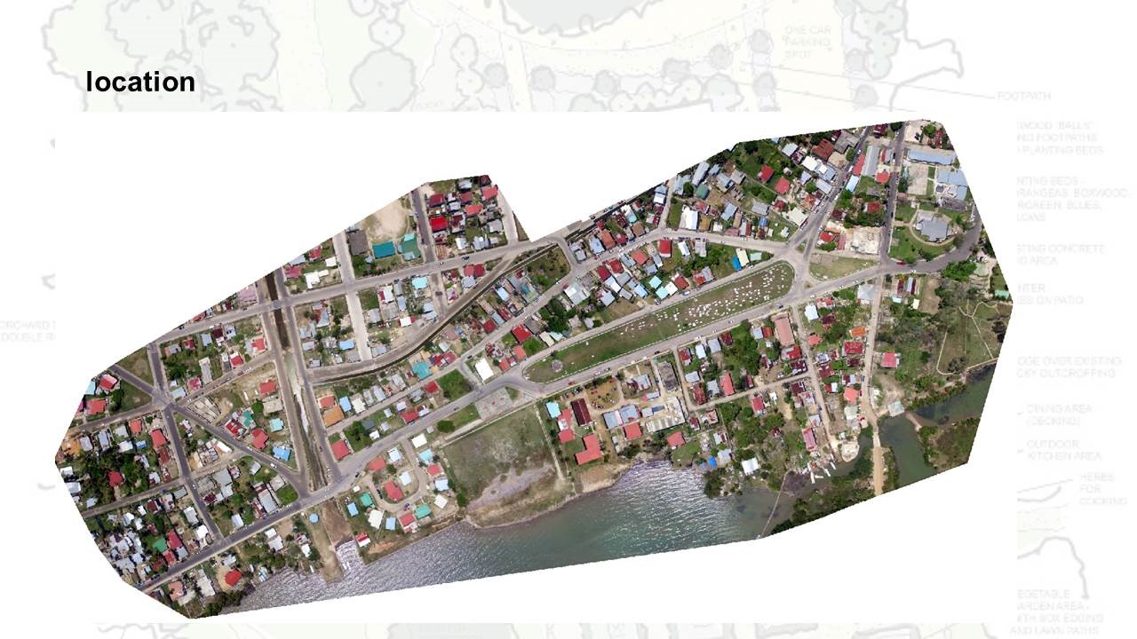
Imagery of Yarborough created with Drone2Map using photos captured by drone
Using Drone2Map, an innovative software recently introduced by Environmental Systems Research Institute (ESRI), Total Business Solutions Limited, the local distributor which sponsored the presentations of Cherrington and Courtenay at the recent forum, stitched together photos collected with a drone by Knight and Day Photography to create a true-to-life representation of the Yarborough area—a hub for education, sports and tourism. This enabled the creation of digital models that could help in the development better elevation profiles for the area.
Cherrrington notes that there is a need for a better digital elevation model for the entire Belize City, which would better help in assessing the vulnerability of the country’s commercial capital not just to flooding but also to sea level rise, and which would additionally aid with planning.
Cherrington also used GIS imagery to show how the City’s landscape has changed over time. He demonstrated how the city has grown between 1980 and 2007, with the addition of new neighbourhoods in places such as Belama and Buttonwood Bay, and land reclamation in the Marine Parade area.
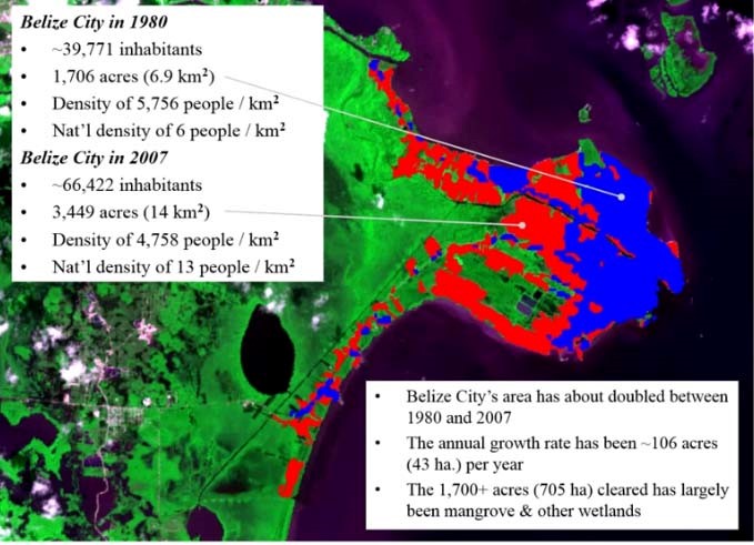
The City’s size has virtually doubled, from about 7 square kilometres to about 14 square kilometres, while population density has fallen from about 6,000 people per square kilometre to about 5,000 people per square kilometre.
As the City continues to grow, there are important questions that GIS can help to answer: Into which areas is Belize City likely to expand? How vulnerable would a particular neighbourhood be to flooding due to storm surge, associated with hurricanes? Where are new or better sea walls required? What are the best locations for hurricane shelters?
These are important questions to ponder as the rainy season also coincides with the hurricane season, and this year, forecasts say that the season will be more active than normal.
For more information, please call 610-1577 or email Lgpalacio@tbsl.bz
 TBSL is an established Belizean IT solutions company that provides high quality and cost-effective business solutions to the corporate market with a management team of 20 years of GIS and business solutions experience combined.